
How Drones Are Revolutionizing Crop and Pasture Monitoring
Discover how a drone's view can help you spot crop issues earlier, optimize your resources, and increase your farm's profitability.
As a farmer, your land is your lifeblood. You know your fields—the low spots that hold water, the sandy ridges that dry out first. You spend countless hours walking or driving the rows, scouting for any sign of trouble. But even with a lifetime of experience, it’s impossible to see everything.
What if you could have a farmhand that could survey every single acre of your property in minutes, and not just see it, but see its health in a way the human eye can't?
That's the power of modern drone monitoring. At Cross Drones, we're not talking about a complicated piece of tech that creates more work. We're talking about a practical tool that delivers simple, actionable information to make your job easier and your farm more profitable.
This is about seeing your crops in a whole new light.
Walking your fields to spot-check for pests or disease is essential, but it's also time-consuming and can be a bit of a guessing game. A drone transforms crop scouting. It can fly over hundreds of acres in the time it would take you to inspect a small section, capturing a high-resolution snapshot of your entire operation. This allows you to spend your valuable time addressing known issues, not searching for them.
See Plant Health Before You Can See Problems
Drones can be equipped with special cameras called multispectral sensors. Think of it like a health check-up for your plants. These sensors see light that we can't, specifically near-infrared light, which healthy plants reflect strongly.
We use this data to create a simple, color-coded map of your field called an NDVI map (Normalized Difference Vegetation Index).
Lush, healthy plants show up as bright green.
Stressed or unhealthy plants—suffering from lack of water, nutrient deficiency, or disease—show up in yellow or red.
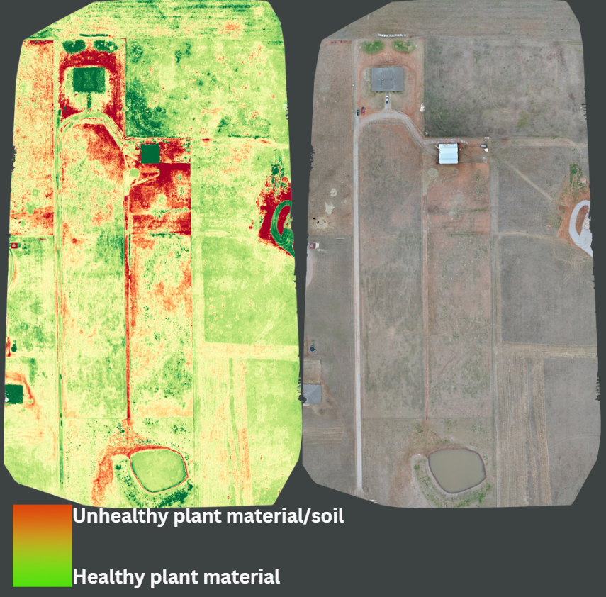
Horse ranch in Apache, OK
The result? You can spot problem areas weeks before they would be visible to your own eyes. This early warning gives you a critical window to act, protecting your yield before significant damage is done. While the science is complex, the map is simple: Green is good. Red needs attention.
Pinpoint Irrigation and Drainage Issues
Is a section of your field getting too much water or not enough? From the ground, it can be tough to tell until the effects are severe. A drone's aerial view instantly reveals patterns in soil moisture and plant growth. You can easily spot:
Clogged or leaking irrigation lines.
Ineffective drainage in low-lying areas.
Areas where water isn't reaching, causing plant stress.
This allows you to fix small irrigation problems before they impact your harvest and to plan more effective drainage solutions for the future.
What This Means for Your Bottom Line
This is about data that drives profitability. By using drone monitoring, you can:
Optimize Inputs: Apply fertilizer or water precisely where it's needed instead of across the entire field, saving significant money.
Increase Yield: Catch and treat disease, pests, or nutrient issues early to minimize crop loss and maximize your harvest.
Save Time & Labor: Drastically reduce the man-hours spent on manual crop scouting.
Make Data-Driven Decisions: Plan your season with confidence using accurate, field-specific information.
Your expertise and intuition as a farmer are irreplaceable. A drone simply gives you a better, more complete view, allowing you to apply that expertise more effectively than ever before. It's an investment in precision, efficiency, and peace of mind.
If this sounds like something you can use, contact Cross Drones today.